AI Unveils Post-Deforestation Landscape Patterns in Africa
Deforestation poses a significant threat to Africa’s diverse landscapes, with forests making way for various land uses. But how does that look from above? With the help of high-resolution satellite imagery and AI, researchers have now unravelled the patterns of land use that emerged after of deforestation across Africa. The findings show a multifaceted tapestry of land uses, encompassing everything from commodity crops like cacao and cashew to more extensive agricultural practices.
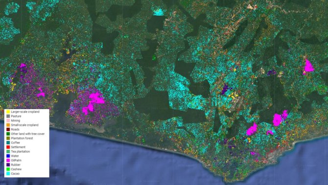
Prior research suggests that agriculture-related land-use change drives deforestation in Africa, but the lack of detailed data impedes identifying specific drivers. Utilising high-resolution satellite data, with an accuracy up to 5 metres, the research team presents the first continental-scale mapping of land use following deforestation in Africa, covering almost 14% of the global forest area. By employing an active learning framework and innovative deep learning models, a method in AI, 15 different land-use types are classified with high accuracy.
This mapping effort reveals a nuanced tapestry of land uses after deforestation, ranging from commodity crops like cacao, cashew, oil palm, rubber, coffee, and tea to mining, pasture, and various scales of agriculture. The study highlights regional variations in forest loss drivers, particularly emphasizing small-scale cropland, which accounts for 64% of total loss from 2001 to 2020.
Need for monitoring
The research team made innovative use of satellite imagery and AI to analyse and categorise post-deforestation land uses. It harnesses cutting-edge technology to create a detailed and dynamic map, offering insights into the varied responses of different regions to deforestation. ‘However, challenges in classifying certain land uses accurately, such as cloud cover and seasonal variations, emphasise the need for ongoing refinement and validation,’ says Robert Masolele, postdoc researcher in geo-information and remote sensing at WUR.
‘Our study underscores the importance of comprehensive, high-resolution maps of post-deforestation land use for informing effective mitigation strategies by African governments, researchers, and forest protection agencies. This research directly addresses the need for improved understanding and monitoring of deforestation related to commodities in the context of new EU climate laws, such as the EU Deforestation Regulation on deforestation-free commodities’, says Masolele.

Next steps: Open Earth Monitor
As part of the ongoing EU Horizon-project Open Earth Monitor, next steps focus on the pantropical expansion and annual updates on post-deforestation land uses. This will serve as a vital monitoring resource for the successful implementation of the new EU climate laws.

