
UC San Diego-Led Science Teams Finalists for NASA Missions on Climate Change
Two teams led by scientists from UC San Diego’s Scripps Institution of Oceanography are among four selected by NASA to put forward concept studies for future satellite missions to help better understand how our planet is responding to climate change.
The proposals are part of NASA’s new Earth System Explorers Program that conducts satellite-based science missions designed to enable Earth system research. The call for proposals for this initiative sought missions that would advance understanding of climate change factors such as greenhouse gases, the ozone layer, ocean surface currents, and changes in ice and glaciers around the world.
“NASA’s selection of not one, but two teams led by UC San Diego is monumental,” said UC San Diego Chancellor Pradeep K. Khosla. “This selection demonstrates our world renowned leadership in earth observation and satellite remote sensing. Through our longstanding institutional commitment to understanding and protecting the planet, UC San Diego is advancing new discoveries, developing policy recommendations and creating solutions for climate change that will benefit all of humanity.”
The two UC San Diego-led teams are helmed by Scripps glaciologist Helen Amanda Fricker and Scripps physical oceanographer Sarah Gille, who have both been involved in prior NASA satellite missions. As finalists, their teams will each receive $5 million to conduct a one-year mission concept study. After the study period, NASA will choose two proposals for satellites to launch in 2030 and 2032, with a budget of $310 million for each chosen investigation.
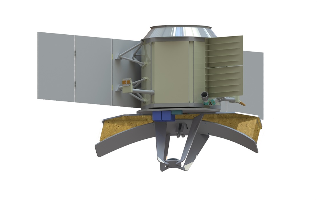
Earth Dynamics Geodetic Explorer (EDGE)
The proposal led by Fricker is called Earth Dynamics Geodetic Explorer (EDGE). Its goal is to observe the three-dimensional structure of terrestrial ecosystems like forests and the surface features of glaciers, ice sheets and sea ice as they change in response to human activity. According to the EDGE team, monitoring these shifting ecosystems and melting polar regions can help science and society mitigate the effects of climate change.
Fricker was a member of NASA’s Ice, Cloud, and land Elevation Satellite (ICESat) Science Team and is the current science team lead for ICESat-2, launched in 2018. These missions use a technology called laser altimetry which sends laser pulses to the Earth’s surface and records the time it takes them to return to the spacecraft. This technology allows scientists to determine the height of the Earth’s surface, and the height and structure of any vegetation. Also in 2018, the Global Ecosystem Dynamics Investigation (GEDI) instrument was deployed onto the International Space Station (ISS), and together these satellites have been vital in monitoring the whole Earth. This research would be brought to bear in EDGE, Fricker said.
“The EDGE team brings together vegetation and cryosphere scientists to work towards a shared goal of developing an instrument to measure these vital signs of our planet,” said Fricker, who also serves as the co-director of the Scripps Polar Center. “EDGE will have the capability to measure the density of the rainforest in the Amazon and depths of individual cracks in glaciers, enabling improved tracking and understanding of our planet’s biodiversity, changes in carbon storage, and rate of ice loss contributing to sea-level rise.”
EDGE builds on and advances the laser technology on GEDI and ICESat-2 through the use of new technology with an increased density of laser beams that will map the planet using five 120-meter wide strips. This provides much higher resolution and accuracy, enabling a more comprehensive view of the dynamics of the Earth’s surface. This unprecedented resolution of the depth, height and structure of terrestrial and ice systems, will allow scientists to precisely measure changes as they are happening. This enables the tracking of carbon stored in forests and ice at the poles, providing a real-time look at how the planet is responding to climate change, and if it is crossing critical tipping points that will cause abrupt or irreversible change.
EDGE will fly on Maxar’s 500 spacecraft, and expand the footprint of our planet that is monitored. The GEDI instrument on the ISS only covers as far north as Canada and south to Chile, but EDGE’s orbit goes all the way to the poles providing global coverage of vegetation and allowing for dense mapping around the edges of ice sheets and sea ice pack.
“Satellites lay down their tracks like wrapping a ball of yarn, with the highest concentration at the top and bottom,” said Fricker. “EDGE’s orbit choice places this concentration in our most critical regions for studying effects of climate change at the poles. The agility of the Maxar spacecraft allows EDGE to target high-priority regions.”
According to Fricker, the data from EDGE will transform understanding of how Earth’s carbon and ice stores are changing. It will be used to inform Intergovernmental Panel on Climate Change (IPCC) reports and policymakers about projected future conditions, helping society prepare for and adapt to climate change.
The EDGE team is comprised of 25 scientists and engineers from around the world, including leadership that includes John Armston from the University of Maryland and Bryan Blair and Scott Luthcke from NASA Goddard Space Flight Center. Scientists from the University of Maryland, U.S. Forest Service, George Mason University, Boise State University, Northern Arizona University, U.S. Geological Survey, Bristol University, National University of Singapore, and the Smithsonian Tropical Research Institution round out the team for terrestrial ecosystem structure, while the ice elevation team features scientists from the University of Washington, University at Buffalo, Colorado School of Mines, the Australian Antarctic Division and Fricker’s alma mater, the University of Tasmania.
Ocean Dynamics and Surface Exchange with the Atmosphere (ODYSEA)
The second UC San Diego-selected concept is led by Gille and called the Ocean Dynamics and Surface Exchange with the Atmosphere (ODYSEA). This satellite will measure ocean surface currents globally for the first time and will simultaneously measure winds over the ocean.
The understanding of the planet as a coupled system requires measurement at the air-sea interface, where the ocean meets the atmosphere. In this transition zone between ocean and atmosphere, clouds form, storms initiate, carbon dioxide in the atmosphere is absorbed by the ocean, and nutrients are transported into ocean ecosystems. ODYSEA will provide understanding of these interactions that is critical to understanding our weather and climate, as well as marine ecosystems.
“ODYSEA fills an important gap in wind and ocean current tracking, and will be a game-changer in understanding how the ocean and the atmosphere exchange gases, heat, and energy, which is one of the greatest challenges in climate science,” said Gille.
Gille has experience with NASA missions for surface winds and sea surface height. She currently leads one of the science teams for another satellite mission to monitor the planet, called Surface Water and Ocean Topography (SWOT), which launched in December 2022.
The ODYSEA satellite will offer entirely new capabilities by measuring daily global surface currents and their interactions with winds, providing data that will improve weather and climate predictions. These data can show how ocean currents influence the atmosphere, and improve weather, climate and ocean circulation models. This information is also useful for search-and-rescue operations and tracking events like oil spills.
The technology powering ODYSEA will be a Doppler scatterometer. Scatterometers use radar signals to measure wind speed and direction. A new innovation, ODYSEA will also measure the speed and direction of surface currents by taking advantage of the Doppler shift in the radar signal due to the motion of the ocean surface. The Doppler scatterometry technique, which forms the basis for ODYSEA, was demonstrated through a prior airplane-based experiment called S-MODE.
Gille likened the Doppler shift to the sound of an ambulance in transit. “This is the reason why the pitch of an ambulance siren changes depending on whether the ambulance is driving toward you or away from you. If the ambulance is coming toward you, the sound waves get shorter and the pitch increases. Similarly, since ocean currents move, they will shift the wavelengths of the returned radar signal detected by ODYSEA.”
The international team led by Gille is a U.S./French collaboration and includes more than 20 partners, including Deputy Principal Investigators Melanie Fewings from Oregon State University and Mark Bourassa from Florida State University, Project Scientist Tong Lee from the Jet Propulsion Laboratory (JPL), as well as French Lead Scientist Fabrice Ardhuin from the Laboratoire d’Océanographie Physique et Spatiale. Other team members are located at Jet Propulsion Lab, the French space agency CNES (Centre National D’Etudes Spatiales), Colorado School of Mines, Woods Hole Oceanographic Institution, NOAA, the US Naval Research Lab, and multiple French research organizations.
Now that Fricker and Gille’s teams have been selected by NASA, both groups will in the next year finalize the technical capabilities of each mission, demonstrate feasibility and refine satellite design so the missions can be executed on time and on budget. NASA will then choose two of the four accepted proposals to move forward to launch.
“The NASA Earth System Explorers Program presents a transformative opportunity to advance our understanding of the planet, and it’s an incredible honor to have two missions led by our outstanding faculty selected for consideration,” said Margaret Leinen, Vice Chancellor for Marine Sciences at UC San Diego and Director of Scripps Oceanography. “I know I’ll be cheering for both of them.”