
University of Bristol Unearths Discovery Shedding New Light on Lost Bristol Landmark
The exact location of a long-lost stone cross erected by the 14th century that acted as a boundary marker to define the then city limits of Bristol, and which was also the site of a gallows which stood for hundreds of years, has been discovered by an historian from the University of Bristol.
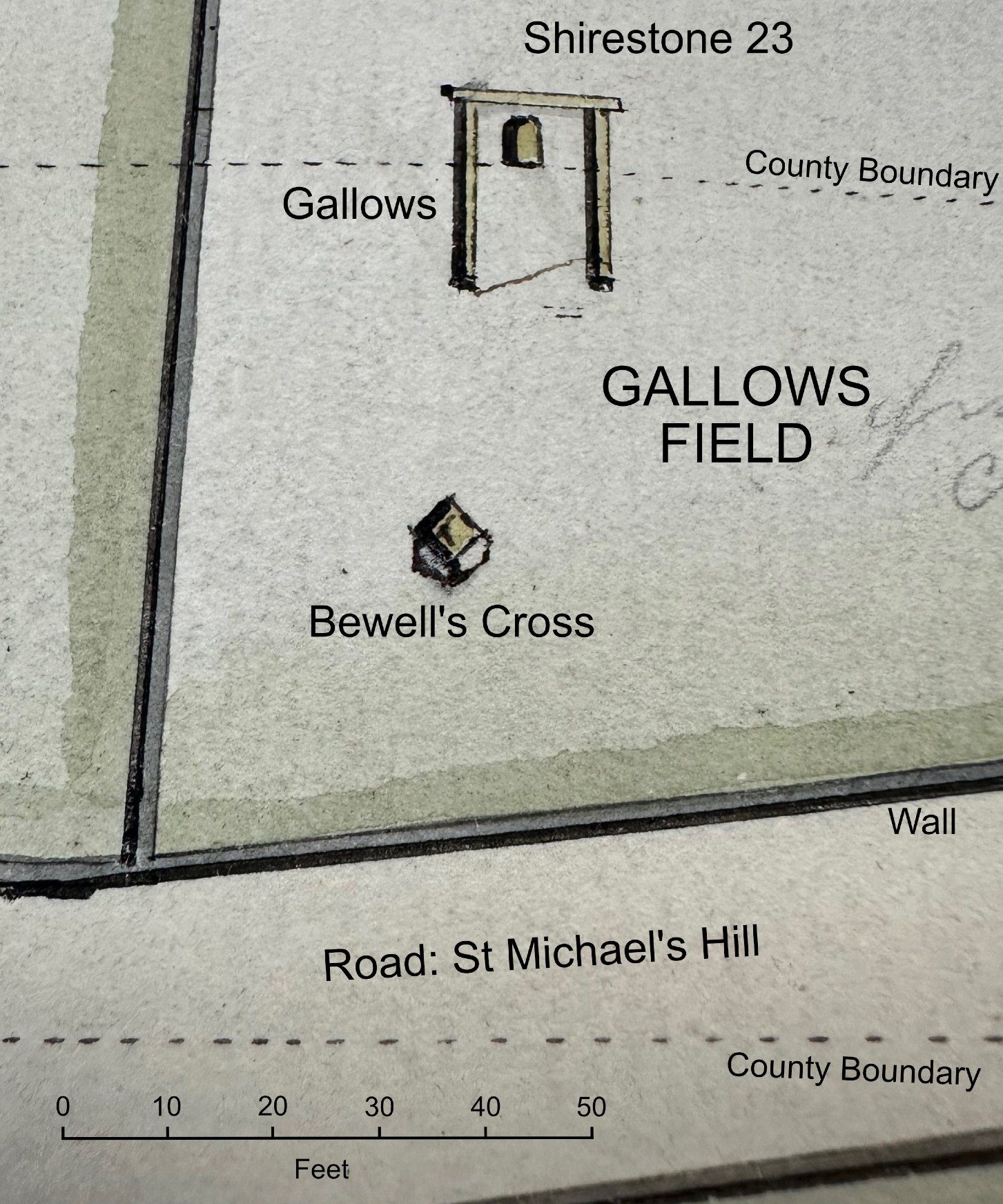
Dr Evan Jones from the University’s Department of History made the observation when he chanced upon a detailed survey of the St Michael’s Hill area of the city which dated from 1792 at Bristol Archives.
The marker – called Bewell’s Cross – stood at the very edge of the medieval county of Bristol. Meaning ‘Bee Well’, it was first mentioned in a charter by Count John [later King] but the first reference to the cross there was in 1373 when the border of the newly established county of Bristol was recorded to define the extent of the shire.
Dr Jones’ discovery has placed its location on the eastern edge of what is now the mini roundabout at the top of St Michael’s Hill.
There were published references to Bewell’s Cross as late as the eighteenth century. In 1789 the Bristol-based antiquarian William Barrett noted that the cross was “where the criminals now usually pray before their execution at St Michael’s-hill gallows”. Despite this, its exact location has long been forgotten, as has its precise position relative to the gallows.
Dr Jones said: “Last year I chanced across a detailed survey of the top of St Michael’s Hill in one of the Plan Books at Bristol Archives. This included a depiction of the gallows, as well as one of the shire stones that marked the county boundary, situated immediately behind the gallows.
“The plan, drawn in perspective, included an object in front of the gallows – a roughly-square three-dimensional object, perhaps 1.2-1.4m across and around 1m high. On the map the object is only a couple of millimetres across and there is no explanation of what it is. So, it was only later that it occurred to me that this might be the base of Bewell’s Cross, minus the cross itself.”
This possibility was confirmed in a later Plan Book which included a detailed 1829 survey of the area, marking out the land that would have to be cleared to lay out a ‘New Road’ – what is now Cotham Road. This plan, which is on a different orientation, recorded the same oblong object, in the same place, with the identical alignment and size as on the 1792 plan.
In 1820 the city’s gallows were moved from St Michael’s Hill to the roof of the New Gaol down on Cumberland Road. So, the gallows itself is not marked on the 1829 plan. It does clearly show, however, that the object that Dr Jones thought might be the base of Bewell’s Cross lay in Gallows Field, right in the path of the new road.
Detail about the destruction of the cross was found in another volume, also at Bristol Archives, which referenced an account by 19th century Bristol bookseller and antiquarian Daniel Vickery who describes how workmen “in laying out the new road now forming from the top of St Michael’s Hill through the Gallows Field to Cotham, the fragment of this once venerated memorial of Christianity has been carelessly fractured, rudely thrown from the spot on which it had stood for ages.” Stones from the cross were then used to build a nearby wall.
Commenting on the precise location of the Cross and the gallows, Dr Jones added: “The results seem disturbingly prosaic. Bewell’s Cross lay on the eastern edge of what is now the mini roundabout at the top of St Michael’s Hill. The gallows where hundreds, possibly tens of hundreds, of people died, straddled what is today a pedestrian crossing point over Cotham Road.
“For half a millennium, this was one of the most symbolically charged places in Bristol, a site of public ‘reality theatre’ that must have troubled the dreams of countless Bristolians. But it is now no longer a place, it is just a meaningless space, a few metres above an anonymous crossing point. I find that both fascinating and strangely unsettling.”