
University of Saskatchewan: Cutting-edge Cartography- Empowering Farmers, Breeders, and Policymakers with a Game-Changing Map
With an area spanning 2.7 million square kilometres – and more than 135 million acres used for farming – this may sound far-fetched, yet Dr. Steve Shirtliffe (PhD), professor in the Department of Plant Sciences at the University of Saskatchewan (USask), is confident not only that this ambition can become reality but also that it will be a valuable tool for agricultural producers and other decision-makers.
“My goal is to map the spatial variability in every field in Western Canada on a 10-metre-pixel scale within the next five years,” he says. “We know how to get there; we have the technology. It’s just about getting the right steps in place to make it happen.”
As project co-lead for USask’s crop phenometrics platform, Shirtliffe studies field phenomics, a process where data from satellites, drones and sensors from agricultural equipment is combined and analyzed through image-processing and machine-learning algorithms to provide insights on field productivity.
“In crop production, the big challenge is to grow more with less,” he says. “It is essential to keep increasing yields in order to feed humanity and exercise our contract with society – which is to provide food, fibre and fuel – in a way that doesn’t adversely affect the environment.”
At the same time, agricultural production is undergoing changes, with climate change affecting weather patterns and growing conditions in the Prairies, for example. Shirtliffe proposes that “digital agriculture can drive a multi-pronged approach to deal with these challenges.”
What gives researchers at USask a considerable advantage are several areas of research excellence that can, taken together, enhance outcomes in agriculture, he says. “We’re at the intersection of remote sensing, data analytics, agronomy and crop science. Bringing these areas of expertise together can help advance plant breeding as well as precision agriculture.”
Digital technologies enhancing crop selection and management
USask has an impressive track record in enabling success in agricultural production, including through “plant breeders, who are selecting and releasing crop genotypes and crop varieties, primarily for Western Canada,” says Shirtliffe.
Previously, plant breeders would go out into fields “with their notepad to look at plant characteristics and record conditions and growth patterns,” he says. “Now, digital imagery allows us to quantify those variables and assess them more accurately.”
Shirtliffe and his collaborative team combine satellite and drone data with ground data – for example, from farm equipment that comes with sensor technology – to generate yield maps.
“All our projects have this aspect of using ground reference data in conjunction with remote sensing data to then train machine-learning models to predict performance for a wider area,” he says. “These techniques allow us to utilize rather sparse data sets and then apply these insights to huge areas.”
There are a number of advantages to using digital imagery: “one, we can collect data from thousands of plots; and two, we can record how these plants are changing over time,” Shirtliffe explains. “Together with experts in engineering, computer science and plant breeding, we developed a methodology for doing that. We also work with geneticists to identify genes associated with particular traits to allow genomic selection and improve plant-breeding techniques.”
“We constantly challenge ourselves to ensure this [research and innovation] ecosystem is as successful as it can be, and to provide answers to some of the big questions of our time.”
Peter Stoicheff, USask President
In addition to better crop selection, the data can help improve crop management. “One of the reasons why crop yields have increased is because we have better crop varieties – another is because we have better ways of managing them,” he says, estimating that influences on crop yields are roughly 50 per cent genetics and 50 per cent agronomy.
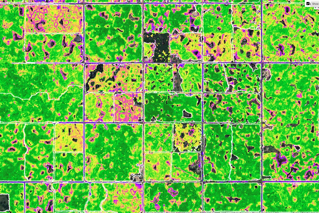
From looking at agricultural production with an agronomy lens, Shirtliffe started using digital imagery to map large areas of the Prairies to quantify crop yield variability existing within fields. “All fields have natural variability, for example, due to variances in soil and water distribution, which are usually the main factors,” he says. “When we’re able to map that – and develop better ways of managing it – we can optimize productivity.”
Identifying high-productivity areas as well as marginal areas can help farmers come up with appropriate management plans, he suggests. “Where marginal areas are not economically profitable, for example, a better approach for that land could be taking it out of production and assigning a different ecosystem function, such as using perennial grasses. This would help sequester carbon, prevent weed growth and provide habitat for wildlife.”
Other questions where Shirtliffe turns to digital imagery for answers relate to the detection of soil salinity and koshia, a weed that causes considerable concern for Prairie agriculture.
Machine-learning models trained on individual field data can be applied to imagery of “thousands or even millions of acres,” he says. “These techniques can be applied very widely due to the availability of data from European and American satellites or that can be accessed on cloud computing platforms like Google Earth Engine.”
Researchers at the University of Saskatchewan are creating methodologies for integrating data from different sources, including satellites, drones and agricultural equipment. (Photo: Dave Stobbe)Researchers at the University of Saskatchewan are creating methodologies for integrating data from different sources, including satellites, drones and agricultural equipment. (Photo: Dave Stobbe)
Research seeding innovation ecosystem
Digital imagery analysis and AI capabilities represent fertile ground for innovation, says Shirtliffe. “It is my hope that we can foster a digital economy here in Saskatchewan. We already have good precision agriculture companies and some smaller enterprises that develop solutions for the sector. We have the right ecosystem to catalyze this and become global leaders.”
USask President Peter Stoicheff believes the university’s presence has played a big role in making Saskatoon one of the fastest growing technology hubs in the country. “And among the fastest growing companies in Canada, a disproportionately large number are located in Saskatoon, with many of them started by graduates of the University of Saskatchewan,” he says. “We’re very much embedded in the innovation ecosystem of this city and region.”
With this potential comes a responsibility to “think about the big challenges the world faces, including food and water security,” he says. “Saskatchewan has almost half of Canada’s prime arable land as well as huge quantities of clean, fresh water – not to mention potash, an important fertilizer. This represents a real opportunity for our university to understand how these resources can make a difference in a world where outcomes are increasingly defined by resource constraints.”
As the world’s population is projected to increase by almost two billion people by 2050, efforts to boost food security are critically important. And the impact of USask research on agriculture has already been substantial, says Stoicheff. “The work that goes on in terms of agriculture, including plant breeding and disease protection, is very significant. We have world-leading expertise and cutting-edge infrastructure, such as the Canadian Light Source, the only synchrotron facility in the country, the Vaccine and Infectious Disease Organization, the Global Institute for Food Security and the Global Institute for Water Security.”
One success story relates to the production of lentils, of which Saskatchewan is now one of the biggest exporters. “The province provides about 50 per cent of India’s total consumption of lentils,” notes Stoicheff, adding that lentils – and pulses in general – have widely been recognized as an important source of plant-based protein to help feed a growing global population.
“We constantly challenge ourselves to ensure this [research and innovation] ecosystem is as successful as it can be,” he says, “and to provide answers to some of the big questions of our time.”
Leadership in food production
Shirtliffe envisions crop phenotyping and digital agriculture tools to become as impactful as other game-changing agricultural innovations spearheaded by USask, such as the no-till system.
“Outcomes from the no-till approach include better soil structure, better moisture conservation, increased productivity, and higher energy and labour efficiencies,” he says, adding that together with continuous cropping, reduced tillage can help promote soil organic matter and carbon dioxide sequestration.
“It is my hope that we can foster a digital economy here in Saskatchewan. We already have good precision agriculture companies and some smaller enterprises that develop solutions for the sector. We have the right ecosystem to catalyze this and become global leaders.”
Dr. Steve Shirtliffe
From tackling Saskatchewan’s soil erosion problems to wide adoption in other grain-producing areas around the globe, no-till brought recognition to USask researchers and led to benefits for Saskatchewan’s equipment manufacturers who export no-till seeding equipment worldwide. In agriculture, embracing new technology takes time, and Shirtliffe has seen this process play out with no-till.
“There was a lot of research and outreach to farmers first, until we had wide adoption,” he says. “With precision agriculture, we already have a very active private industry offering related services to farmers to differentiate themselves from other agronomic solution providers.”
USask has developed a Precision Agriculture Certificate, where students get exposed to technologies used to measure and manage variability in crop production, he says. “Students are very keen on this program, and I had a wonderful teaching experience this year.”
Beyond teaching and research, Shirtliffe envisions to “add a lot of value to the [agriculture] industry when we’re able quantify the variability in productivity for individual fields – and the key factors causing this variability.
“Rather than just having a really cool map, our main goal is to use these tools for making a positive impact for plant breeders, crop producers and food production in general,” he adds.