
University Of Miami Experts On Destruction Of Hurricane Season
Throngs of Gulf and East Coast residents undoubtedly let out a collective moan last May when forecasters at the National Oceanic and Atmospheric Administration (NOAA) released their 2022 Atlantic hurricane season outlook.
An ongoing La Niña and warmer-than-average sea-surface temperatures would fuel another active season, they predicted.
Then, something unusual happened: From July 3 to the end of August, the Atlantic had no named storm activity, marking the first time since 1941 that has ever happened, according to Colorado State University hurricane researcher Phil Klotzbach.
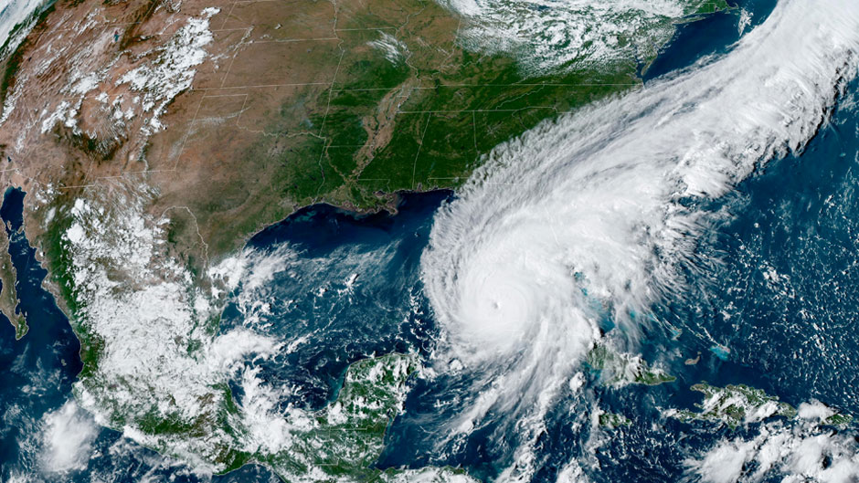
But after an unusually calm first half, the season ramped up, with three destructive storms in the second half, punctuated by Hurricane Ian, which pummeled parts of Southwest Florida with devastating winds and storm surge on Sept. 28.
Three hurricanes formed in November (Lisa, Martin, and Nicole), tying 2022 with 2001 for the most Atlantic hurricane formations on record for that month.
By the time the 2022 season came to its official end on Nov. 30, 14 named storms had formed, of which eight became hurricanes and two intensified to major hurricanes with winds reaching 111 mph or greater.
“The overall numbers tell the story of a fairly typical season. But when you zoom in to the specific events and distribution of activity, it was anything but typical,” said Brian McNoldy, senior research associate and tropical cyclone expert at the University of Miami Rosenstiel School of Marine, Atmospheric, and Earth Science.
The dearth of storm activity in July and August was especially surprising for a La Niña year. Indeed, the phenomenon, which can contribute to an increase in Atlantic hurricane activity by weakening wind shear over the Caribbean Sea and tropical Atlantic Basin, remains robust, according to Ben Kirtman, a professor of atmospheric sciences at the Rosenstiel School.
“[Saharan] dust certainly was one factor in the smaller-than-expected hurricane activity,” Kirtman said. “Another element, however, is that seasonal hurricane forecasts have significant uncertainty and need to be interpreted from a probabilistic perspective. For example, the official [midseason] seasonal forecast for 2022 was for a 60 percent chance of above normal, 30 percent chance near normal, and a 10 percent chance of below normal. Obviously, what this means is that if we repeated the same environmental conditions for 10 different hurricane seasons, six would be above normal and three would be near normal. We just happened to sample the near-normal outcome in this case.”
It was the strangely quiet August that was unanticipated, McNoldy said. “Several factors came together during July and especially into August to suppress tropical cyclone activity,” he said, noting cooler-than-average ocean temperatures in the tropics, drier-than-average air in the mid-levels of the atmosphere, and stronger-than-average vertical wind shear across the tropics.
The season was below average when it comes to accumulated cyclone energy, or ACE, which essentially measures the overall intensity and duration of storms; it is not a measure of the number of storms.
“ACE can be thought of as a type of kinetic energy but with a greatly simplified formula,” McNoldy explained. “To calculate it, one squares the peak wind speed value of an active named storm every six hours and then sums those values over the lifetime of a storm. That is done for all named storms, and they all get added together. Short-lived and/or weak storms do not contribute much, while long-lived and/or strong storms contribute more.”
During this past season, Fiona accounted for 28 percent of the total, while Ian was down in second place at 18 percent. The other 12 storms contributed the remaining 54 percent. This year’s total ended up at 95.1, which is 80 percent of average and the lowest total since 2015, according to McNoldy. “In the NOAA seasonal outlook criteria, that value falls in the middle of the near-normal range,” he said.
But while the 2022 Atlantic hurricane season can be described as near normal, it is still considered a bad one considering the death and destruction caused by Ian. Estimates put storm damage into the billions, and Ian will surely be one of the 10 costliest hurricanes in U.S. history. What’s worse, the hurricane killed at least 148 people, many of those in coastal communities that were overwhelmed by storm surge.
“The phrase ‘It only takes one’ is one we should all keep in mind,” McNoldy said. “Whether there are two or 12 hurricanes in a season, if any one of them makes landfall near you, it’s going to be a bad year.”
A busy year for hurricane experts
The season, while near normal, kept the University’s hurricane researchers busy, as they studied storms using a variety of different techniques—from deploying instruments into the ocean and atmosphere to flying directly into hurricanes aboard Hurricane Hunter aircraft to take critical readings.
In collaboration with NOAA’s Hurricane Research Division and the Naval Research Laboratory, Lynn “Nick” Shay, a professor of ocean sciences at the Rosenstiel School, and his team deployed a combination of ocean expendables and atmospheric GPS sondes simultaneously over the Caribbean Sea. “We were planning to deploy more expensive assets such as profiling floats and salinity/current profilers until [Hurricane] Ian jogged eastward over the very shallow water over the west Florida Shelf,” Shay said.
Shay’s preliminary findings suggest extensive upwelling over the shelf because of Ian’s slow speed. “However, the water being upwelled was also quite warm, which is an example of less negative feedback to the atmosphere,” he said. “This is one reason the storm stayed intense. This also has implications for stirring up red tide organisms that reside over the shelf and shelf break. The resuspension of these organisms coupled with the freshwater runoff from the Caloosahatchee River into the bays made the ecosystem ripe for amplification of the red tide. So, it is no surprise that red tide occurred after the storm.”
Shay, whose Sanibel Island home was heavily damaged by Ian, also found that the strong currents and waves forced by the hurricane’s winds were principally responsible for damaging the Sanibel Causeway, the series of bridges that connect mainland Florida to the island. A 15-foot storm surge pounded the causeway for several hours, Shay pointed out.
“It is important to note that it was the previous day, before Ian hit, that NOAA nearly doubled its surge forecast from 6-to-9 feet to 12-to-18 feet,” he said. “So, once again the research underscores the importance of the three-dimensional flow fields excited by strong winds that drive sea level and surge and upwelling and downwelling processes,” he explained.
Historic flights
A busy second half of the season meant Jason Dunion, a scientist at the University’s Cooperative Institute for Marine and Atmospheric Studies, and his team of researchers logged several hours from September through the first week of November flying into the heart of storms aboard NOAA Hurricane Hunter aircraft.
In August, he led a first-ever historic deployment of Hurricane Hunter aircraft to the Cape Verde Islands to probe the region where many of the most powerful hurricanes are born. “That was truly a trailblazing effort to extend NOAA’s operations to a part of the Atlantic we had never flown before,” Dunion said.
During Hurricane Earl, he and his team flew 20 missions over 12 consecutive days, taking readings of the storm from when it was just a disorganized tropical disturbance to its peak as a Category 2 hurricane. The data on Earl helped build forecast models on the storm, was used in real-time by forecasters at the National Hurricane Center, and will be studied by research scientists to improve our understanding of storm genesis, Dunion noted.
Rosenstiel School Ph.D. student Alexis Wilson, who is studying the genesis of tropical cyclones, flew two missions aboard a Hurricane Hunter out of St. Croix in the U.S. Virgin Islands this season, helping to monitor data from the aircraft’s tail doppler radar (TDR) and deploying a dropsonde weather device.
“Interestingly, the data we collected from the TDR and the dropsondes on my first flight helped the National Hurricane Center declare Lisa a tropical storm, while my second flight gave us information on the strength and structure of Lisa before it made landfall,” Wilson said. “These flights were an invaluable learning experience, one that I hope to have the opportunity to repeat in the future.”